FT-RF

Earth Observation

LEO satellites are used for high-resolution imaging of the Earth's surface, enabling applications such as urban planning, agriculture monitoring, disaster management, and environmental protection
Remote Sensing
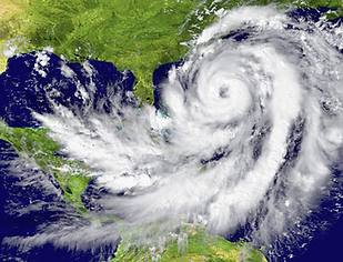
These satellites gather data for weather forecasting, climate monitoring, and atmospheric research, aiding meteorology, climate modeling, and studying natural phenomena like hurricanes and wildfires.
Communications
They facilitate global broadband internet access, especially in remote or underserved areas, through constellations of small satellites providing low-latency, high-speed internet connectivity


Navigation and Positioning
LEO satellites contribute to accurate positioning, navigation, and timing services, supporting applications like GPS navigation, vehicle tracking, and precision agriculture.
Surveillance and Security
They are utilized for border surveillance, maritime monitoring, and security applications, providing real-time monitoring of large areas and facilitating rapid response to security threats.


Environmental Monitoring
LEO satellites help monitor changes in the environment, including deforestation, pollution, and ice melt, supporting conservation efforts and sustainable development initiatives.
